Council: Levee changes won’t worsen downstream flooding
Bob Pieper For Chronicle Media — August 9, 2017
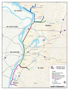
Metro East system of Mississippi River levees
(Map courtesy of U.S. Army Corps of Engineers)
Mississippi River levee renovations, designed to protect Metro East from up to 100-year flooding levels, are now on track for completion in November 2017, according to Chuck Etwert, chief supervisor of Construction and the Works for The Southwestern Illinois Flood Prevention District Council.
Further renovations, to protect the area from up to 500-year flooding, are now scheduled to begin in summer 2018, Etwert said.
With major flooding increasingly common along the Mississippi over recent years, a growing chorus of critics contends that levee overbuilding is to blame.
However, Metro East’s massive levee update — designed to protect the American Bottoms area from Alton to Columbia — will not adversely affect areas downstream, Etwert emphasizes.

Chuck Etwert, chief supervisor of Construction and the Works for The Southwestern Illinois Flood Prevention District Council.
“There has been a lot of talk lately about levees being raised and flooding areas elsewhere. Everything that the Council is doing is to stabilize, not raise, the existing levees, to prevent seepage either thru or under the levees,” Etwert said.
Levee overbuilding is likely to be a topic as the federal Mississippi River Commission (MRC) a presidentially-appointed advisory body, conducts its annual low-water inspection trip and public hearings along the river Aug. 7-18.
New U.S. Army Corps of Engineers surveys indicate numerous Mississippi River levees upstream of Metro East exceed their authorized height; allowing them to channel more flood water down the river and thereby effectively increase flood levels downstream.
Some 40 Mississippi River levees in the corps’ Rock Island District — which extends from near the river’s Minnesota headwaters to about 60 miles north of Metro East — are overbuilt, according Army Corps data. Together, they represent more than a third (about 80 out of 202 miles) of the protective Mississippi River levee constructed north of the American Bottoms.
Most commonly cited for exceeding authorized heights is the Sny Island Levee and Drainage District, the largest levee district upstream of Metro East, which extends from Quincy to Belleview.
In all, the new Army Corps data shows at least ten levees upstream of Metro-East exceed their authorized height by more than two feet.
Mississippi River flooding in Metro East during Dec. 2015-Jan.2016 was the third highest on record and flooding in April of this year was the sixth highest, Etwert notes.
Such statistics serve to underscore the importance of plans to provide 500-year flood protection for Metro East, he says. However, he contends that the Southwestern Illinois Flood Prevention District will not contribute to flooding problems downstream in the way that, critics say, the overbuilt levees upstream may be exacerbating flooding problems in Metro East.
“We are not raising any portion of the levees located between Alton and Columbia. These levees were built in the 1940’s and improved in the ‘50s by the Corps of Engineers as 500-Year levees. They are all at the proper height and are not being raised.”
Heavy flooding over the past two years has hindered progress on the Metro East levee renovations, Etwert acknowledges. Originally, the district had hoped to have all work completed by the first half of 2017. The district’s governing board now hopes to have all work completed by November – assuming river elevations recede as usual during the summer months.
“The good news is that through May 31st, $71.1 million of the total of $74.4 million in construction work has been completed. We are over 95 percent done, with just over $3 million in work left to complete,” Etwert said.
The other good news, according to Etwert: “With the recent flood event (last month), all of the Council’s improvements built to date, performed as designed and no problems were experienced. It was a good test of the levee system.”
The Southwestern Illinois Flood Prevention District Council was formed in July 2009 by Madison, Monroe and St. Clair counties, to undertake levee renovations after the Federal Emergency Management Agency (FEMA) announced plans to de-accredit the 65-mile levee system protecting the Metro East region.
Sections of the massive levee system had experienced seepage during the flood of 1993.
“FEMA’s decision would effectively designate substantial portions of the American Bottom area of Southwestern Illinois as a Special Flood Hazard Area (SFHA) on new flood insurance rate maps, with devastating economic impact on our region,” the council notes on its website.
SFHAs are areas in which the National Flood Insurance Program’s (NFIP’s) floodplain management regulations must be enforced by FEMA under federal law, and purchase of federal flood insurance is mandatory, according to the FEMA website.
To finance levee renovations, Metro East political leaders sought authorization from the Illinois General Assembly to impose a one-quarter percent sales tax to pay for necessary improvements.
—Council: Levee changes won’t worsen downstream flooding —


